KANAZAWA
Hakusan Cycling: Pedaling Through Nature and Centuries of History Part 1
Looking for a good bicycle ride in Japan? Of all the cycling routes I’ve ridden in this country, the Tedori River is my favorite. Located in Ishikawa, just a 30-minute train ride from Kanazawa City, it flows from the foot of Mount Hakusan, which is second only to majestic Mount Fuji (or perhaps third, depending on who you ask), all the way to the Sea of Japan. The Tedori River passes through the UNESCO Global Geopark Hakusan Tedorigawa and if it’s nature you’re looking for, it doesn’t get much greener than this! So grab a bicycle and get riding.
UNESCO Global Geopark Hakusan Tedorigawa: https://g.co/kgs/WMxZnFS
©Keri Yazawa
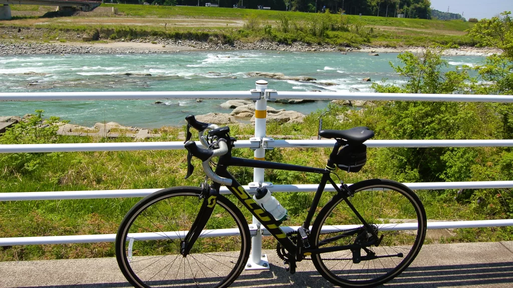
A good place to start your ride is Tsurugi Train Station. It’s a 30-minute train ride from Kanazawa City (Nomachi Station) and rental bicycles are available. There are light-weight cross bikes and powerful electric bicycles, too. If you’re riding in summer or aren’t interested in literally mashing pedals on your vacation, I’d go with the electric. Let the bicycle do the grunt work while you just enjoy the ride.
There are two directions to choose from: cruise down the Tedori River until you get to the seaside, or head uphill toward the mountains. (Don’t worry – it’s not that much of a challenge.) Either way, plan to ride at least 20 miles roundtrip.
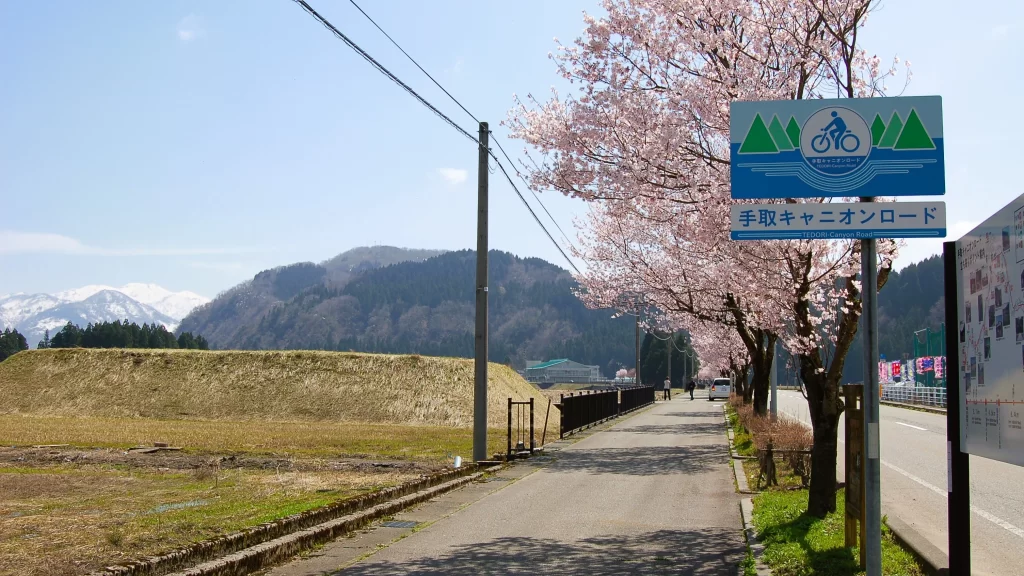
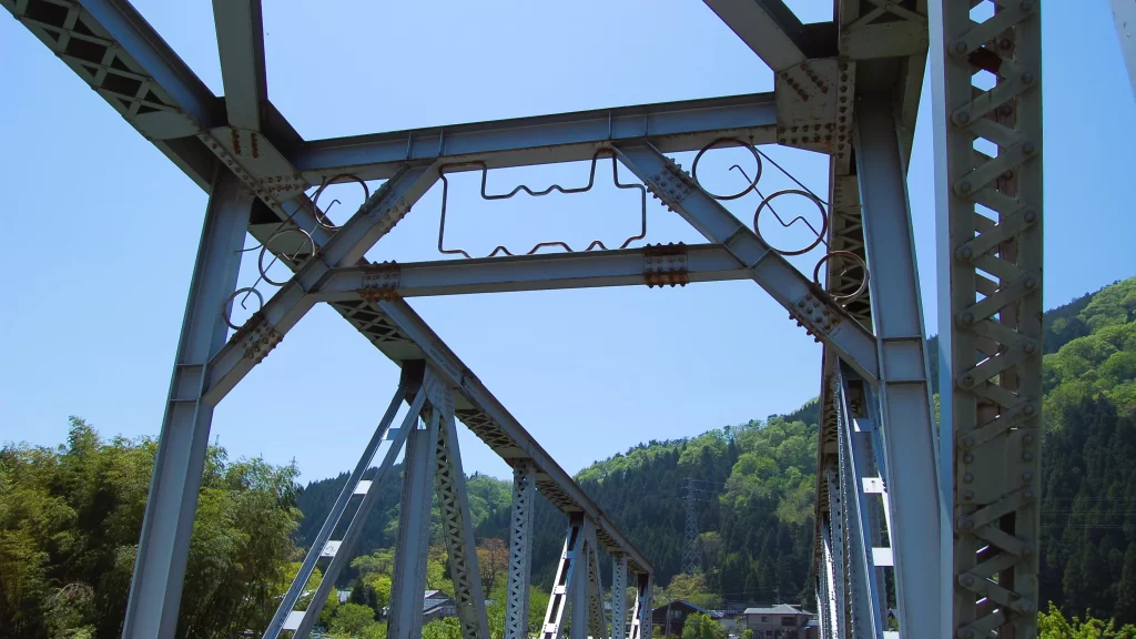
As there are more interesting sights upriver than down, let’s head up the valley toward the mountains on the Tedori Canyon Road. The first checkpoint on your ride explains why you’re not slogging up steep terrain: the old railway bridge.
Tsurugi Train Station: https://maps.app.goo.gl/y6pbU8stNHNQC4JX6
Tedori Canyon Road: https://maps.app.goo.gl/ymN8aK7huco4mwJk7
©Keri Yazawa
Yes, this cycling road used to be a train line, so the grade is a pretty gentle climb of about 2%. You’ll definitely notice it if you’re on a heavy conventional bicycle, hence the light-weight cross bikes and electric options.
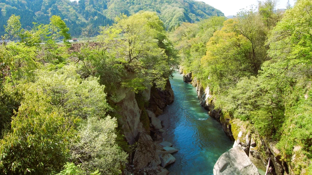
When this portion of the train line was discontinued, the local communities decided to pave it for use as a cycling road. Elements of both trains and bicycles have been incorporated into the bridge design, but you might miss those details if you’re busy staring at the gorge beneath you, where the mint-green water of the Tedori River froths between rocky walls and swirls around massive boulders.
©Keri Yazawa
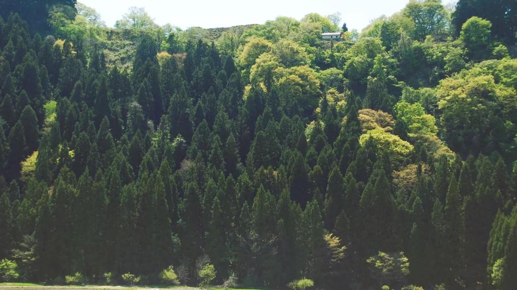
Riding on and crossing the main road, you’ll continue along the cycling trail past small hamlets and seas of rice fields that are planted in May and start getting really green and lush in June. Before you cross the main road again, you’ll come upon an old, rickety mine sorting operation on your right. Seriously, this thing looks like it could have been built by the dwarves in Disney’s Snow White. It may look quiet and derelict, but it’s still in use and has been for decades.
If you’re riding the Tedori Canyon Road in spring, you’ll soon be treated to a long line of cherry blossoms as you cycle beside the main road.
Kawai Mine Sorting Operation: https://maps.app.goo.gl/xwBZq91WyANXaUT36
©Keri Yazawa
In the fall, the leaves of the cherry trees turn orange and red, their vibrant colors continuing on for at least a mile.
When you reach a 3-way intersection, you have the chance to take a trip back in time to the Warring States Period (1467-1567…ish); turn right and ride up through the tunnel to the roadside market of Ikkou-ikki no Sato. Set back beyond the parking lot is a museum that tells the story of how the local farmers and fishermen and craftsmen successfully rose up against their feudal lord with the encouragement of some pot-stirring Buddhist monks. This grassroots resistance (called ikkou-ikki) popped up north, south, east, and west of Kyoto as the people got fed up with their respective lords taxing the living daylights out of them in order to pay for their trivial battles. For nearly a hundred years (1478-1574), the people here had no lord and paid no taxes. They funded no wars and kept to themselves.
But alas, all things must come to an end.
Ikkou-ikki no Sato: https://maps.app.goo.gl/5pWNC91hLZ3YWNqM
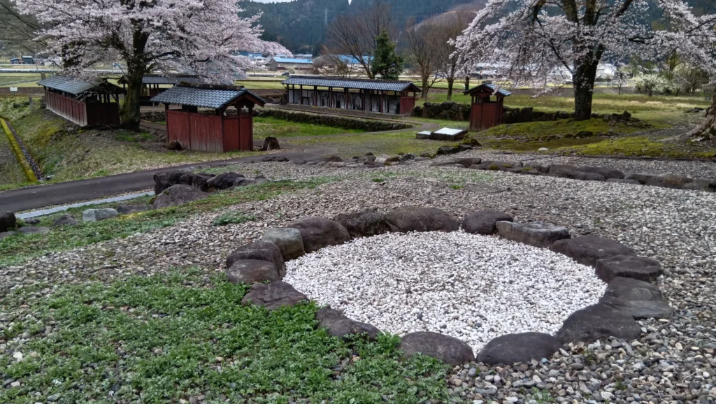
If you turn away from the museum and look out toward the lone hill surrounded by rice fields, you’ll be gazing at the site of the wooden fortress that once stood at its summit. This is where about 200 farmers, armed with rifles, held their ground against an army of samurai in 1574.
©Keri Yazawa
They made their last stand up there, fighting for the freedom to govern themselves. The fortress itself is long gone although the stone well remains and one of the wooden gates has been rebuilt, but if you want a better idea of what the freedom-fighters’ fortress might have looked like, you’ll have to check out the dioramas in the Ikkou-Ikki Historical Museum. The exhibits are all in Japanese, of course, so bring a translator (be it a guide or an app on your phone).
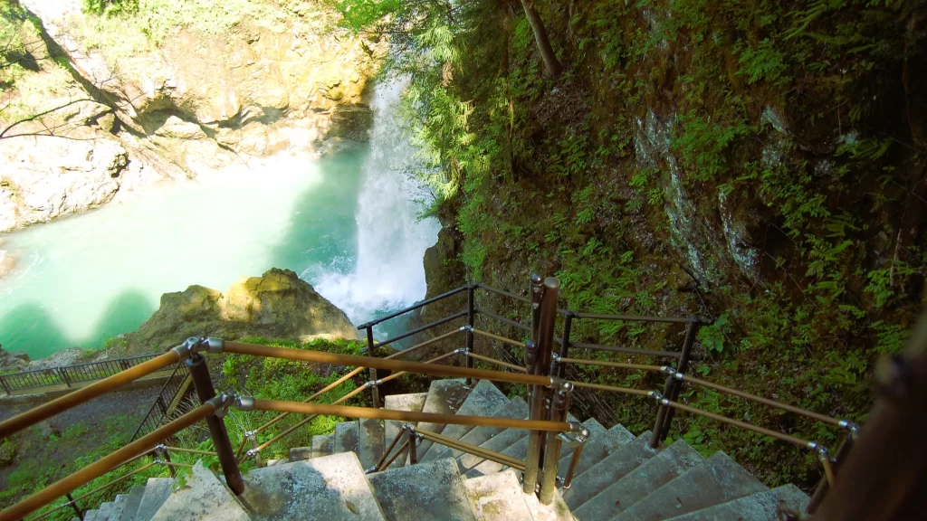
Yes, history can be a bit of a downer, so I’ve saved the best for last. Get back on your bicycle and head back the way you came through the tunnel to get back on the cycling road. After about 3 miles, you’ll arrive at Tedori Gorge’s 105-foot-tall Watagataki Waterfall. It won’t look like much when you first arrive: just a yellow restroom building and a parking lot. To see the falls, you’ll have to take the stairs (about 140 of them) down into the gorge.
Ikkou-Ikki Historical Museum: https://maps.app.goo.gl/8f1q7Y48i21icydJA
Tedori Gorge’s: https://maps.app.goo.gl/ocKMEULDpr8faYLg9
©Keri Yazawa
If you’re not eager to go down and up again, there’s also a wooden pavilion just a 5-minute walk from the parking lot (downriver from the restrooms) where you can get a near-bird’s eye view of the waterfall.
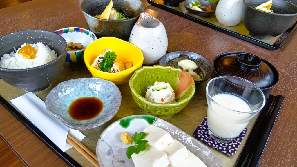
At this point, you could call it a day and start the return trip back to Tsurugi. But if you’re up for a challenge, keep going until you run out of cycling road. Follow the lines and arrows to the left, over the orange bridge and then up, up, and up to the Roadside Station Sena where you’ll be met by a souvenir shop and restaurants Denko (for tofu, noodles, and desserts!), Yamaneko (for coffee and ice cream!), and Hakusan Pass Teahouse (for a hotpot with udon noodles!).
Roadside Station Sena: https://maps.app.goo.gl/Xk54C1ooQ2BeMNZ68
Denko: https://maps.app.goo.gl/HDGoGmQJ9bEmC4o59
Yamaneko Kijitora Coffee Roastery: https://maps.app.goo.gl/4cm3LkDcYvEcg91Y9
Hakusan Pass Teahouse: https://maps.app.goo.gl/Vxz3p569y9StXHEXA
©Keri Yazawa
Other cafes, bakeries, and restaurants along the Tedori Cycling Road include: Nonohana (for the dessert set!), Kamino (for spicy Thai green curry!), Pan-no-Mimi (for crispy-chewy curry-filled buns!), Ikki Soba (for tempura and buckwheat noodles!), Ikkou-Ikki no Sato Roadside Station (for more buckwheat noodles!), Detza (for green salad and quiche!), Niwaka (for even more buckwheat noodles!), and Kobo (for single-origin coffee and the softest chiffon cake you’ve ever had).
Nonohana Cafe: https://g.co/kgs/Xvir5z6
Kamino Cafe: https://g.co/kgs/bxshXkk
Pan-no-Mimi: https://maps.app.goo.gl/CXVbNAn1gezwSijt6
Ikki Soba: https://maps.app.goo.gl/tur1TQjVK316rXjx9
Ikkou-Ikki no Sato Roadside Station: https://maps.app.goo.gl/5pWNC91hLZ3YWNqMA
Detza: https://maps.app.goo.gl/EniJYhksRT9q8GyG6
Niwaka (Niwakakobo): https://maps.app.goo.gl/oYm9w3d9rjXzUA9u6
Kobo Google Maps Location: https://maps.app.goo.gl/ophBEQHPhCeUWE8E7
About Keri Yazawa
Keri Yazawa, a resident of Kanazawa City since 2005, guides bicycle tours specializing in good food, quirky history, local craft making, and gorgeous landscapes.
©Keri Yazawa